Research
Air Pollution
Air pollution poses tremendous challenges to human health, ecosystems, and food security. The adverse health impacts of PM2.5 and ozone can be attributed to their precursor emissions, which can be directly controlled. We improve the understanding of air pollution problems by:
-
Quantifying air pollutant emissions using atmospheric observations
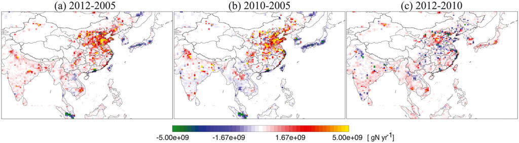
We more accurately quantify the magnitudes, spatial distributions, and trends of NOx, SO2, and CO emissions using multi-scale observations, data assimilation, and data-driven approaches.
-
Performing source attribution of ozone and PM2.5 to identify the most effective ways to achieve healthy air quality levels
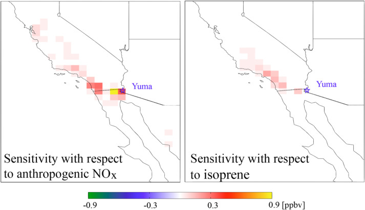
In the example above, sensitivity analysis shows that emission reductions in California and Mexico will be the most effective measures to reduce ozone exceedance in Yuma, Arizona.
Atmospheric Methane
Atmospheric methane is the second most important anthropogenic greenhouse gas. An improved understanding of methane emissions is a top priority for carbon research and for climate policy stakeholders. Methane has an atmospheric lifetime of 9 years, making it a near-term climate forcer with an impact comparable to carbon dioxide on a 20-year horizon. Reducing methane emissions is therefore an important lever to slow down rapid climate change, and has co-benefits for improving ozone air quality and for fuel recovery.
We use statistical methods and observations to analyze the factors driving recent trends of atmospheric methane concentrations. This method has been applied to analyze the regional methane emissions (e.g., North America, Mexico, China) and emissions from the oil and gas production regions. This approach significantly improves the accuracy of methane emission inventory and can further attribute methane sources from different activities and sectors.
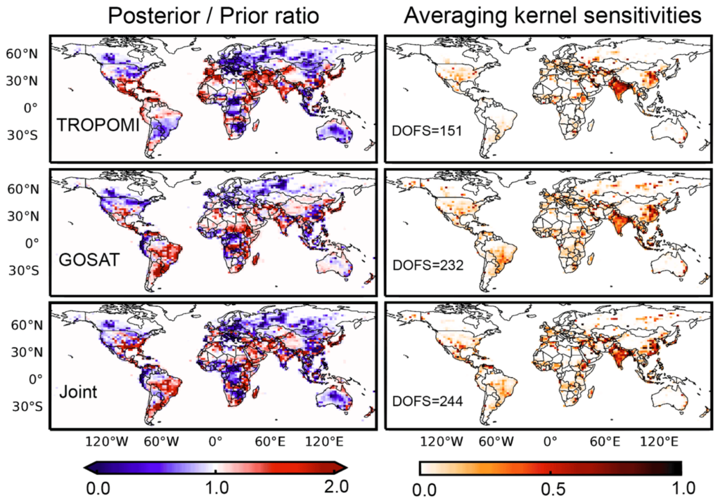
The figure above shows the emission corrections and information we gained from different instruments. We also evaluate the robustness of using these observations in estimating emissions These results provide important support for the Global Stocktake in support of the Paris Agreement by the United Nations Framework Convention on Climate Change.
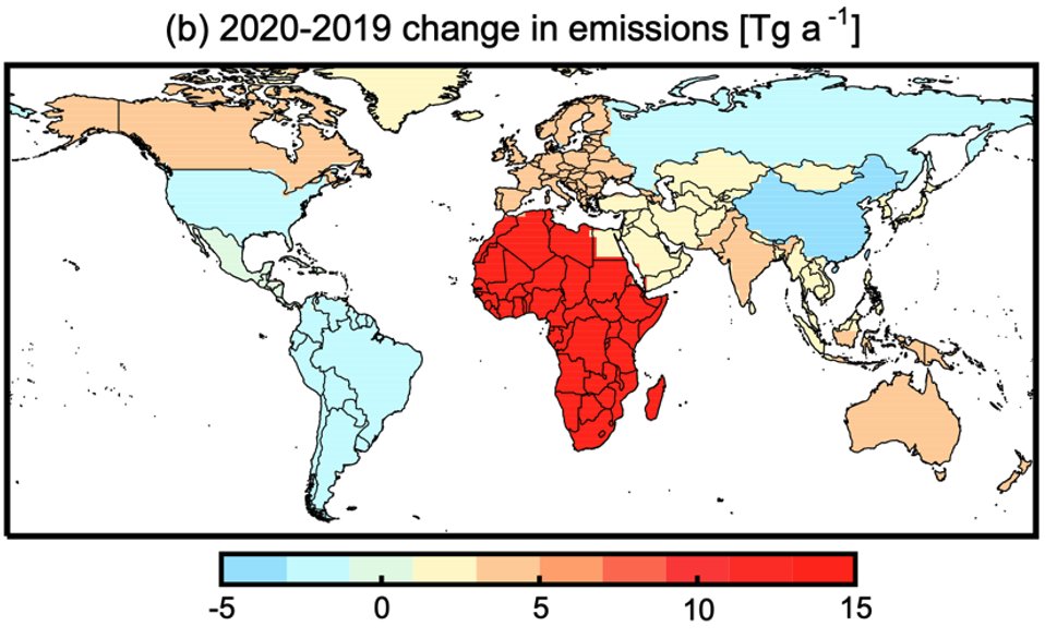
We also perform source attribution of the 2020 surge in atmospheric methane by inverse analysis of methane observations. The figure below shows that half of the increase is attributed to Africa and is likely caused by wetlands. Our finding of wetlands as the principal driver for the 2020 surge could be a harbinger for the response of atmospheric methane to climate change.
Algorithm Development
We explore how multi-scale observations combined with data science and physical models advance our understanding of the magnitude, spatial distribution, and trend of air pollutants by applying statistical methods and these observations. This is important for identifying manageable emissions, tracking emission regulation progress, evaluating environmental justice efforts, and mitigating air pollution and climate change.
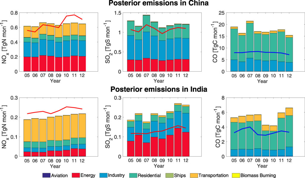
The figure above shows a new inversion framework we developed to account for chemical interactions and estimate activity rates and species emission factors using atmospheric observations.
Topics we care about